Drone/unmanned aerial vehicle (UAV) detection apps are becoming more and more useful as the demand for drones continues to rise. According to Statista, there are over 3.6 billion people that use smartphones today. Why wouldn’t you want to find out how to detect a drone in the sky?
But is there actually an app you can download that detects drones?
Yes, there are several apps that detect drones. DroneWatcherAPP and AirMap are both popular apps capable of detecting drones. However, there are some limitations to these drone detection apps.
DroneWatcher APP
DeTect is a company that specialises in several sensor technologies such as advanced radar. In 2016, they released an app made for the Android operating system that is capable of detecting a drone in your area.
We are of course talking about the DroneWatcherAPP.
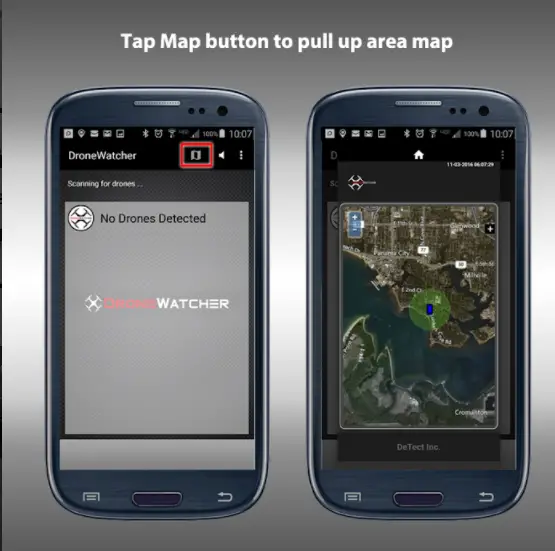
This app can be used on Android phones and tablets and is capable of detecting small consumer fixed-wing, rotary-wing, and even flapping-wing unmanned aerial vehicles while running in the background without you even noticing.
The DroneWatcherAPP was made to detect, track and notify you when a drone is in your area. It is capable of detecting a drone when it is within 1/4 to 1/2 a mile from you.
This app is also capable of recording the drone type and its ID which can be used against the drone’s operator if the drone is being used in illegal or harmful ways.
It can detect most non-encrypted radio frequency (RF) controlled consumer drones that use wifi to communicate. This can be a limitation of the app as not all drones use non-encrypted RF. It cannot detect many small toy drones, drones that use encrypted data protocols or military drones.
This app is meant to be used in conjunction with the DroneWatcherRF and the Harrier drone surveillance radar (DSR). These are however not free and not suited for everyone.
There is a paid pro version of this app which will allow for direction finding and allow multiple devices that use the app to be linked in order to cover a larger area monitoring zone.
Pro features will also provide expanded web services including a real-time, interactive web display of the covered area with color-coded monitoring zones, audible and visual monitor alerts, text message alerting, and downloadable data logs.
Drone Watcher APP – Apps on Google Play
This app is not perfect, but it’s free! So why not give it a try?
AirMap For Drones
AirMap is an app that does a lot more than just detect UAVs in your airspace. AirMap is available on both IOS and Android devices.
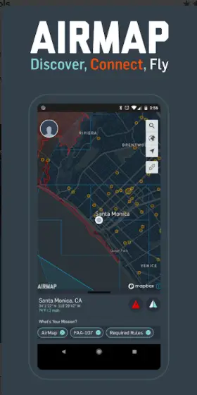
This app gives you real-time feedback of airspace rules and regulations for 20 countries such as the United States, United Kingdom or Canada among others according to your chosen flight path.
You can plan a flight path to your specific duration, altitude and airspace requirements.
You can choose between multiple map styles. This app will let you know where most of the no-fly zones are located so that you never run into any legal trouble.
You can connect to many drones such as DJI models as long as they’re supported.
If you’re planning on using your drone for commercial purposes, you can request authorisation digitally in LAANC-enabled United States controlled airspaces.
However, many recent issues are beginning to cause anger and frustration for some users.
AirMap is beginning to add paywalls that may cause anger for many as they do not believe you should have to ‘pay to fly’.
Some experience the app crashing whenever they try and request authorisation and incompatibility issues with certain phones.
You may occasionally run into outdated maps of your area which can be frustrating.
These are just issues to be aware of but they may not affect you at all! They could be resolved at a later date, but for now, these are still happening to certain users.
Nonetheless, this app is still a great app that can make your experience flying a drone much better and safer for you and others in your area.
What Are Some Other Ways To Detect And Track Drones?
The methods mentioned above are not the only ways drones can be detected.
Drones can be detected with PTZ cameras, radar and radio frequency (RF) technology.
We are only going to briefly go over this as we already have a post that dives deeper into this here:
Related Post: Can Drones Be Tracked? Detailed Guide To Drone Detection
PTZ cameras are used to detect drones due to their ability to zoom, tilt and pan. They have many features such as the ability to use night vision, capture high definition footage and detect drones at incredible distances.
Radar technology is used by emitting RF waves 360 degrees in every direction. These signals reflect off of an object and is amplified by the radar antenna allowing it to detect and determine the shape and size of an object.
Radio frequency (RF) spectrum is used by many drones today in order to communicate between the drone’s operator and the drone itself. There are RF scanners capable of detecting these RF signals and therefore detecting a drone in the sky.
Conclusion
Although drone detection apps may not be the most accurate, they are certainly very handy multipurpose tools that can aid you in multiple ways that exceed simply detecting drones.
The apps mentioned above are considered some of the best for this sort of application.